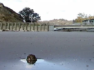


Here comes the wharf piling!
The lump on the left is the top of one of the wharf pilings from the old Aptos wharf. As the winter goes on and the sand migrates away, the pilings will stand taller and taller. The sandstone bluff on the upper left is shaped much as it was over 100 years ago.
What the Heck are those posts marching out into the sea?
Did you know that Aptos was once an international port?
Each winter, the coastal sands go away for a time, exposing the remnants of the wharves that once ringed the Bay of Monterey. Every coastal town that amounted to anything had its own wharf, and Aptos was no exception. Usually, around the first of January, the pilings of the Aptos wharf emerge to remind us of the time when Aptos was an international port of embarkation.
Aptos Had Three Wharves
Aptos actually had a series of three wharves, each longer than the previous, their landward end resting at the foot of the bluff west of the mouth of Aptos Creek. Because of the west to east drifting of current and sand, all three major wharf systems on the Santa Cruz County side of Monterey Bay were located on the "upstream" or western sides of their respective creek mouths. Santa Cruz, Soquel (present-day Capitola) and Aptos all had wharves on their stream's western edges.

Aptos Wharf and Aptos, c. 1882. Taken during the Spreckels era looking north, this rare photograph shows the sandstone bluff that is part of today's Seacliff State Beach. The treeless hills in the distance are what we now call Aptos Village, while the buildings visible to the right of the wharf are part of Spreckels' hotel complex. The railroad tracks on the wharf were used to move cargo on small horse-drawn railcars. No railroad locomotives ever came out on the wharf. Photo Credit: Preston Sawyer Collection, University of California, Santa Cruz.
The first Aptos wharf was built in the 1850s and was owned by Rafael Castro. Castro owned over 6,000 acres of land stretching many miles on both sides of Aptos Creek, land that had been granted to him by the Mexican government in 1833. (The Aptos Rancho was a Mexican land grant, not a Spanish land grant as is often written. There were no private grants made during the Spanish era--1770-1822--in what is now Santa Cruz County.) Castro's wharf was only five hundred feet long and was used to ship hides, flour, redwood lumber and firewood during the 1850s. In 1867, Titus Hale leased Castro's wharf (it had begun to collapse by then), repaired it and extended it five hundred more feet into the sea. Hale also shipped redwood lumber and agricultural products from the surrounding countryside, but his primary business was cutting and shipping oak firewood to San Francisco. By November of 1867 there was over 4,000 cords of firewood awaiting shipment off the wharf, and San Franciscans considered Aptos oak to be the best firewood on the market.

The Aptos Wharf Road. The only other clue remaining about the old wharf is this short stretch of road that intersects with Soquel Drive in Aptos just west of the railroad trestle. Present-day Soquel Drive was once the main road between Santa Cruz and Watsonville. Wagons loaded with lumber or agricultural products would turn here and head directly south dropping down off the coastal terrace and bringing their cargoes out onto the Aptos wharf for shipment
In 1880, international entrepreneur Claus Spreckels repaired the wharf and extended it to its maximum length of 1,300 feet. Spreckels had purchased most of the Aptos Rancho from Rafael Castro in 1872, and by 1880 he wished to export Santa Cruz County redwood lumber to build his various projects in the Hawaiian Kingdom. The broadgauging of the railroad that passed through Aptos in 1883 made it possible for Spreckels to ship large quantities of redwood by rail, and when he was thrown out of the Hawaiian kingdom in 1886, the Aptos wharf was no longer necessary in his plans. The ocean quickly knocked sections off the neglected wharf so that, by 1889, it was only 600 feet long. By the turn of the century only the occasional fisherman used it, and soon thereafter it finally collapsed.
Today, besides the piling that is just beginning to peek its head above the sand, the only other remnant of Aptos' maritime heyday is the narrow road that intersects Soquel Drive just west of the railroad trestle. Named, appropriately, Aptos Wharf Road, the road lines up directly with the pilings beneath the sand to the south. The Highway 1 freeway now cuts off direct access, but if you could fill in the freeway, you could walk south and follow the route of the cordwood, lumber and agricultural products that were once the economic mainstay of Aptos.